
In analysis of satellite imagery released today, the Sudanese Armed Forces (SAF) appear to have used a temporary non-conflict zone around the airfield at the centre of the UK-managed evacuation from Sudan, while staging airstrikes against paramilitary rebels in the Rapid Support Forces (RSF).

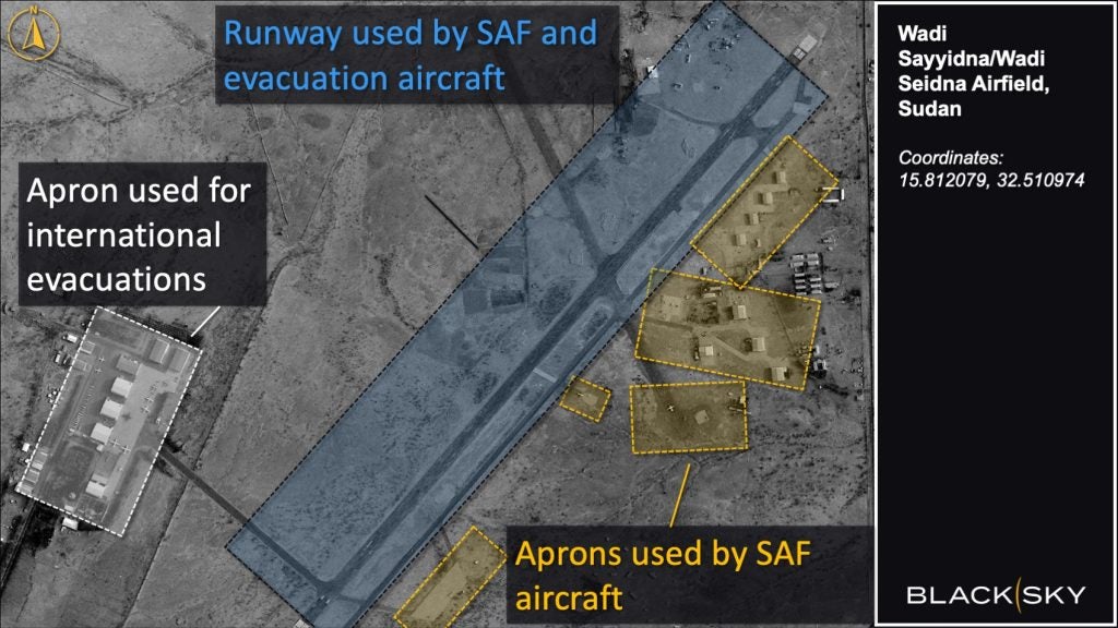
Satellite imagery from BlackSky, a major geospatial intelligence provider, taken during the SAF/RSF ceasefires, show Sudanese military aircraft using the Wadi Seidna airfield concurrently with international evacuation flights, according to an intelligence analyst familiar with the location and imagery.
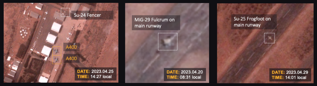
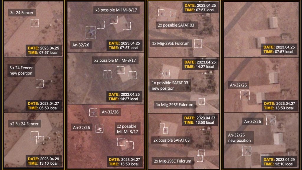
Intraday satellites images of the main runway at Wadi Seidna airfield show the presence of a Sudanese Mig-29 Fulcrum on 20 April and a Sudanese Su-25 Frogfoot on 29 April, as well as numerous Sudanese aircraft and helicopters, throughout the period of the evacuation, appearing and disappearing from the runway-apron between image captures.
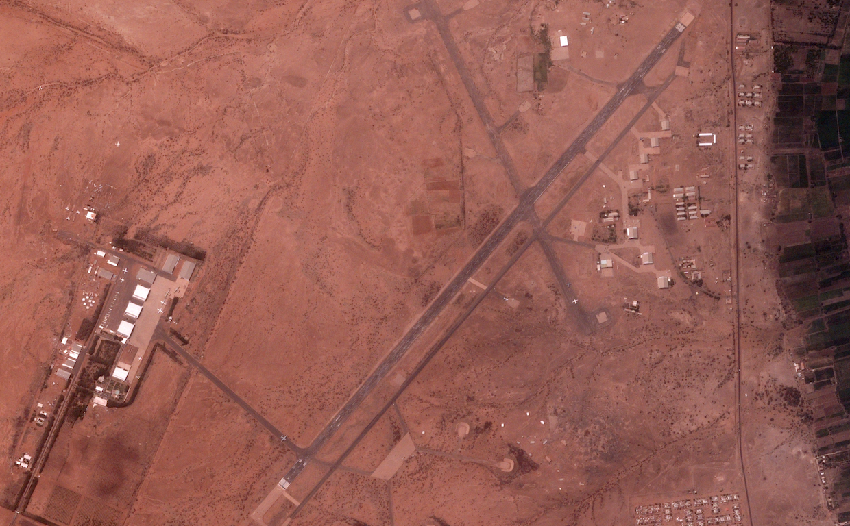
Wadi Seidna military airfield served as the UK’s primary location for evacuating UK nationals and their dependants from Khartoum during the early stages of the conflict in Sudan. The UK Joint Task Force conducted more than 20 evacuation flights at the site before it ‘handed over’ operations to the SAF, according to a Ministry of Defence statement from 2 May.
During this stage of the conflict, reports emerged of air strikes being conducted throughout Khartoum: a Mig-29 Fulcrum was filmed firing an air-to-surface missile against a target on 15 April, as reported by Military Watch Magazine; the Armed Conflict Location & Event Data Project (ACLED) found that at least 5 airstrikes had occurred in the Khartoum area between 23-30 April; and Crisis24 reported SAF airstrikes against RSF positions in Omdurman and Khartoum North on 28 April.
In a report from 4 May, researchers at Human Rights Watch found that, “Only the Sudan military is known to possess and operate SAF aircraft in Khartoum,” raising the implication that between the RSF and SAF, only the SAF could have been responsible for these attacks.
While lacking any air power at the time, the RSF was in possession an anti-aircraft capability sufficient to attack Sudanese aircraft operating at Wadi Seidna airfield.
A CNN investigation published on 21 April charted the supply of Wagner surface-to-air missiles to RSF, through a Libyan intermediary. A little over a month later the US accused Wagner of supplying surface-to-air missiles to RSF, as reported by Al Jazeera on 25 May.
In its 4 May report, Human Rights Watch researchers also verified video of RSF rebels operating an anti-aircraft cannon in a densely populated area of Khartoum, west of the Khartoum International Airport.
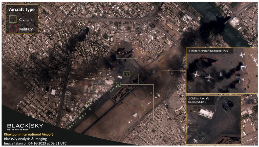
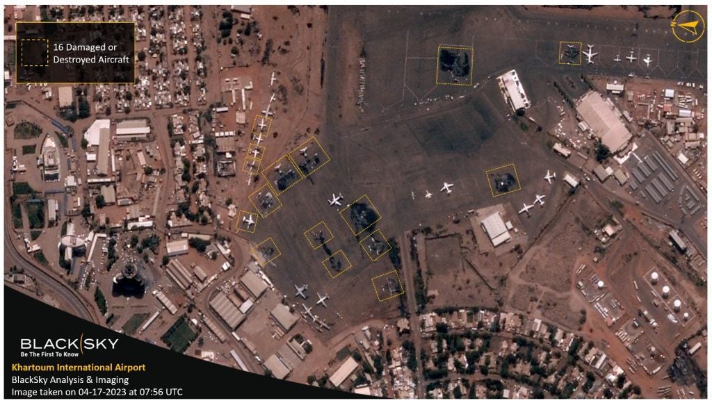
On April 15, 2023, when fighting between the RSF and the SAF initially erupted, violent activity was concentrated near Khartoum International Airport, causing damage to airport structures as well as the destruction of many aircraft stranded on the tarmacs. The airfield was quickly rendered inoperable, and the country’s civilian airfields were closed. The aircraft detection and classification models developed by BlackSky allowed for rapid analysis of the impact of the fighting on aircraft on the ground, including identifying the aircraft being destroyed as military aircraft parked closest to government buildings near the airfield.
Four months into the conflict, over 3,000 people have been killed, and 6,000 injured. While evacuation operations were able to return approximately 20,000 foreign nationals to their home states, Sudan has seen more than 500,000 people driven to become refugees, and more than two million people have become internally displaced.
The low-latency satellite imagery collected by BlackSky of Sudan is a function of the novel structure of its 16 satellite constellation. Orbiting along the Earth’s equator, the constellations pattern of movement is in contrast to conventional geospatial intelligence companies that operate satellites along polar orbits. Although the area covered by BlackSky’s unusual pattern of orbits is smaller, it still captures 95% of the human activity related to gross domestic production worldwide.
This pattern of orbit also means that the BlackSky constellation can return to a site with a much higher frequency. Most people on earth will be under a BlackSky satellite every hour, and BlackSky can return satellite imagery within 90 minutes of any request. The industry standard elsewhere is to handle requests within a few days or a week.
The lack of violent action against Wadi Seidna airfield during the evacuation drives questions as to whether that the RSF were enjoined to respect a temporary non-conflict zone at Wadi Seidna, while SAF aircraft operated freely from the site. With a range of approximately 3-7km, even a small man-portable missile system would be capable of reaching Wadi Seidna airfield from areas accessible to the RSF.
However, while ACLED recorded that the RSF was engaged in more than a hundred violent events across the Khartoum region between 15-30 April, there was only one violent event recorded at the airfield during the whole time-frame: a small calibre round that damaged a Turkish C-130, requiring minor repairs.
As noted in the Ministry of Defence release from 2 May, as a consequence of repairs conducted British Army Royal Engineers, necessitated by the high volume of international flights crossing deteriorating the surface, the Joint Task Force were returning the airfield to Sudan’s senior representative ‘in a better condition than when the UK took over coordination of evacuations at the airfield.’
The UK Foreign, Commonwealth and Development Office and the Ministry of Defence have been asked for comment, but have not replied with a response at the time of publication.
