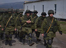

Crimea, Russia/Ukraine
The Russian annexation of Ukraine’s Crimea region has escalated territorial and border disputes between both nations causing instability in Ukraine and the formation of a new interim government led by President, Oleksandr Turchynov.
Go deeper with GlobalData
Discover B2B Marketing That Performs
Combine business intelligence and editorial excellence to reach engaged professionals across 36 leading media platforms.
Crimea was taken over by the Russian Empire during the rule of Catherine the Great in 1783 and remained part of Russia until 1954, when it was transferred to Ukraine under the then Soviet leader Nikita Khrushchev.
In the wake of the 2014 Ukrainian revolution, unmarked Russian troops seized control of Crimea. The Republic of Crimea later held a disputed referendum that passed with 96% in favour of joining Russia. Ukrainian Armed Forces subsequently withdrew from Crimea in March 2014 but despite ceasefire agreements between Russia, Ukraine and rebels; armed conflict.
West Bank and the Gaza Strip, Israel/Palestine
The West Bank and Gaza Strip are Israeli-occupied territories administered in accordance with the Interim Agreement referred to as Oslo II Accord. A "seam line" separation barrier is being constructed by Israel along parts of the Green Line and within the West Bank.
The Gaza Strip came under the administration of Egypt after the 1948 Arab-Israeli War and was captured by Israel during the Six-Day War in 1967. Under agreements signed between 1994 and 1999, Israel transferred security and civilian obligation for a number of Palestinian-populated areas of the Gaza Strip as well as the West Bank to the Palestinian Authority (PA). Following the death of Palestinian leader Yasir Arafat in late 2004, Mahmud Abbas from Fatah political party became the PA president.
US Tariffs are shifting - will you react or anticipate?
Don’t let policy changes catch you off guard. Stay proactive with real-time data and expert analysis.
By GlobalDataIsraeli forces subsequently withdrew from the Gaza Strip and four settlements in the West Bank in 2005, but continue to control air space, maritime and other approaches to these areas. The Islamic Resistance Movement, known as HAMAS, took control of the PA government after winning the Palestinian Legislative Council election in early 2006. In the aftermath violent clashes dominated the region causing a split between Fatah and HAMAS in 2007. At present HAMAS controls the Gaza Strip, whereas the West Bank is governed by the PA.

Golan Heights, Syria/Israel/Lebanon
The Golan Heights is a Syrian territory occupied by Israel in the 1967 Six-Day War, which created the Purple Line. Much of the southern Golan Heights was invaded by Syrian forces before being repelled by Israeli forces during the Yom Kippur War. A ceasefire agreement signed between Israel and Syria in 1974 transposed a major portion of the Golan Heights area to Israel.
Lebanon, which also shares border with the Golan Heights, claims a small portion of the land known as the Shebaa Farms which was occupied by Israel during Operation Litani and the area is administered as part of the Golan Heights. A portion of the Golan Heights, which farms part of demilitarised zone, is under the military control of UN peace keeping forces.
About 350 peacekeepers from the United Nations Truce Supervision Organization (UNTSO) based in Jerusalem observe and supervise ceasefire and truce agreements in the region.
Nagorno-Karabakh, Armenia/Azerbaijan
Nagorno-Karabakh is a disputed region between Armenia and Azerbaijan. The self-declared Nagorno-Karabakh Republic has witnessed frequent breaks in ceasefire resulting in hostilities due to the failure of mediation efforts and force deployment by both the nations.
Despite 95% population of Nagorno-Karabakh being ethnically Armenian, the area is internationally recognised as being part of Azerbaijan. The conflict over the territory officially concluded in 1994 with a ceasefire agreement signed after a six-year war. Tensions, however, escalated in 2014 due to border clashes resulting in more than a dozen fatalities on both sides.
Increased tensions are anticipated to disrupt oil and gas exports from the region as Azerbaijan is one of the major oil and gas exporters to Europe and Central Asia. As the nation produces 850,000 barrels of oil a day, the current conflict is expected to have a major affect on the oil and gas market.

Line of Control (LOC), India/Pakistan
Line of Control (LOC) is the military control line dividing the Indian and Pakistani-controlled portions of the former princely state of Jammu and Kashmir. Originally known as the Cease-fire Line, it was renamed LOC, abiding by the Simla Agreement signed in July 1972. The 740km-long veered line follows no well defined geographical characteristic.
The part of the early princely state under Indian control is referred to as the State of Jammu and Kashmir. Controlled by Pakistan, the two parts of the former princely state are known as Gilgit-Baltistan and Azad Jammu and Kashmir (AJK). LOC is considered one of the world’s most dangerous border lines with frequent skirmishes.
The Indian Armed Forces laid a 550km fencing barrier along the disputed LOC. The fence mostly covers 150 yards on the Indian-controlled side and includes land mines. The purpose of the barrier is to prevent arms importation and infiltration by Pakistani-based separationist militia groups.
Korean Demilitarised Zone, North Korea/South Korea
The Korean demilitarised zone (DMZ) is a 250km-long and 4km-wide, buffer zone separating North and South Korea. The new border was created under the 1953 Korean Armistice Agreement following the establishment of the Republic of Korea (South Korea) and the People’s Republic of Korea (North Korea) in 1948.
The DMZ divides the Korean Peninsula into northern and southern parts, while extending west to east roughly along the 38th parallel, with the west and east ends lying south and north of the parallel respectively.
Since the establishment of the de facto border line, numerous clashes and incursions involving North Korea have been reported. South Korean, the UN, and the US forces discovered four underground tunnels dug by North Korea through DMZ into South Korean territory between 1974 and 1990. North Korea, however, denied direct involvement in any of these.

Aksai Chin, China/India
Aksai Chin is one of the major disputed border areas between China and India. The area, which is governed by China as part of Hotan County in Xinjiang Autonomous Region, is also claimed by India as a portion of the Ladakh district in Jammu and Kashmir.
China and India fought in the Sino-Indian War of 1962 over Aksai Chin and Arunachal Pradesh. The two nations, however, signed agreements in 1993 and 1996 to fête the Line of Actual Control (LAC).
In April 2013, a three-week repulsion occurred among Indian and Chinese forces 30km southeast of Daulat Beg Oldi near the Aksai Chin-Ladakh LAC. Negotiations between the two nations continued for about three weeks, and the dispute was resolved in May causing both sides to withdraw.
Abkhazia and South Ossetia, Georgia/Russia
Abkhazia and South Ossetia are two partially recognised breakaway republics in the Caucasus region situated between the Black and the Caspian seas. South Ossetia and Abkhazia declared independence from Georgia in the early 1990s. The Russian Federation as well as few UN member states recognised the two states, but Georgia considers them as Russian-occupied territories.
Abkhazia and South Ossetia came under control of Russia after the Russo-Georgian War and Russian military bases were established in the two republics after the war in 2008. Russian forces subsequently withdrew from Georgian territory under a ceasefire agreement negotiated by the President of France, Nicolas Sarkozy and the European Union.
The demarcation of the South Ossetian boundary in Shida Kartli began in 2011. Russian troops are installing security fence to separate the South Ossetia from the rest of Georgia, but the law of Georgia on Occupied Territories accords the entry into the two breakaway regions only from Georgia.

United States/Mexico
The US has 3,200km of border with Mexico and installed protective barriers between the two countries. The border area between San Diego in the US and Tijuana in Mexico is considered one of the world’s most dangerous borders.
The varied barrier systems on the border across the urban areas consist of a secondary barrier with a "No Man’s Land" in the middle, whereas the most violent areas frequented by illegal aliens and drug smugglers include an improved triple barrier with an anti-climb plate.
According to US Department of Homeland Security statistics revealed in 2014, 300 border incursions by Mexican military and law enforcement authorities were recorded since 2004 of which, 152 incidents involved armed subjects.
Senkaku / Diaoyu Islands (East China Sea), Japan/China
The dispute over Senkaku (Diaoyu in Chinese) Islands in the East China Sea has severely degraded affairs between Japan and China. The Islands, controlled by Japan and claimed by China, are uninhabited, but lie in an area containing potential oil and gas reserves.
According to the Japanese government, the nation surveyed the islands in 1885 and confirmed that the Islands were inhabited and Terra nullius (Latin: land belonging to no one). China recognised Japanese sovereignty until 1970s but afterwards claimed (along with Taiwan) that the islands were not under the control of Japan prior to the First Sino-Japanese War.
The Japanese government’s acquisition of three of the disputed islands from a private owner in 2012 caused protests in China. The establishment of "East China Sea Air Defence Identification Zone", including the Senkaku Islands, by China further escalated tensions between the two Asian countries.
.gif)