

Global positioning system (GPS) data has transformed the way soldiers navigate and acquire targeting information in the field. Having reliable information showing where each unit, vehicle and aerial platform is at all times increases situational awareness for both soldiers and commanders. GPS is also central to the way targeting information is acquired for many weapons systems. As a result, access to a reliable and accurate GPS signal in the field has become a highly valuable asset in modern warfare, and has led to increased use of systems designed to interrupt or jam the signal.
Go deeper with GlobalData

Discover B2B Marketing That Performs
Combine business intelligence and editorial excellence to reach engaged professionals across 36 leading media platforms.
The challenge to protect GPS signal for mounted units is making headway, with armed forces investing in developing more secure anti-jam signals, and providing alternative data sources for navigating and targeting in the field in the event of signal loss. However, the challenge for the dismounted soldier remains, as many of the solutions under development and in use are too heavy to be of practical use. The dismounted soldier is also at a greater disadvantage in the urban area, where signal can be lost when a soldier enters a building and there is no clear line-of-sight with the GPS signal.
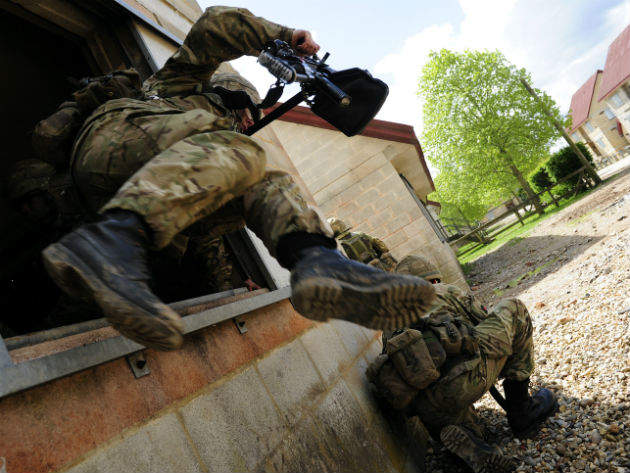
Dismounted close combat sensors
The UK’s Defence Science and Technology Laboratory (Dstl) is one of a number of organisations targeting this critical gap in the reliance on GPS function for the dismounted soldier.
“Positioning information is critical to many military functions,” a Dstl spokesperson said. “In particular location knowledge is important not specifically for the individual soldier’s use – they are all skilled in map and compass navigation – but for informing the wider situational awareness of colleagues and commanders. This in turn helps prevent blue on blue incidents, increases operational tempo and improves the chances of operational success.
“Furthermore, in order to let others know where the enemy is, the target-hand-off system has to accurately know where the soldier is. The challenges of having accurate positional information are particularly acute in the urban environment where urban canyons, RF reflections and building interiors present particularly difficult navigational challenges.”
Dstl has teamed up with industry partners Roke Manor Research, QinetiQ and Systems Engineering and Assessment (SEA). Together they have developed a new solution called the dismounted close combat sensor (DCCS), designed to improve navigation, automatically detect threats and share this information with other soldiers and commanders.
The new system uses inertial and visual navigation sensors when GPS signals are not available. Taking the last known GPS location, DCCS combines information from visually tracked features captured by a helmet camera and inertial sensors, accurately calculating where an individual is, allowing people to be tracked in buildings and tunnels.
“The key technology is based on vision based navigation and the close coupling (sensor fusion) of this with an inertia navigation unit,” the spokesperson said. “This integrated visual navigation system is then integrated with high-quality GPS and algorithms developed to understand when GPS can or cannot be trusted and to smoothly transition between the navigation systems when it is most appropriate to do so.
“It works by providing a number of different navigation options, then carefully selecting the most trustworthy component at any particular time. There is a need to measure the sensor output but also to carefully monitor the noise and errors with each sensor and fuse the output accordingly.”
The system’s applications are wider than simple navigation. A combination of camera, laser and orientation sensors mounted on the personal weapon will allow soldiers to highlight targets to other troops, unmanned aerial vehicles and aircraft at the press of a button. The idea is that this will be quicker, easier and less confusing than giving verbal instructions, while also being extremely accurate. Other uses include identifying wounded personnel, the location of civilians and potential helicopter landing sites.
In addition, acoustic and camera technology will provide a fire detection capability, automatically identifying where enemy weapons are being fired from, even if the individual hasn’t seen or heard them being discharged. This information will then be relayed to the user and to commanders, allowing them to take appropriate steps to deal with the threat.
Demonstrating innovation
The main goal of the DCCS development project is to demonstrate and identify a technical route forward for technology that keeps the dismounted soldier in the GPS loop in urban areas. The team has tapped into the basic strengths within UK industry to develop the sensor, and is now looking to take this innovation to the next level.
“The basic strength is around the ability to understand and exploit navigation sensors, particularly the development of image based navigation algorithms that operate in real time with minimum computation/power requirements,” the spokesperson said. “Then to package these as a system-of-systems which intrinsically understands which sub-system to use of position reporting at any given point, depending on the environment it finds itself in.”
The DCCS was demonstrated by the team in September 2016 with positive results. The system was put to the test in a number of different environments, each of which was designed to create specific challenges for the system.
The challenge going forward is to increase the system’s robustness so that the operator knows that they can trust the system irrespective of the environment to the same extent that GPS signal can be trusted in the field.
Technology-wise, the team is currently working to identify funding to increase technology readiness levels and reduce the system’s size, weight and power requirements.
It is hoped that the demonstration programme will provide vital know-how to inform future wearable sensor technologies with the aim of seeing DCCS type systems enter service with British forces by 2020.
