
For today’s increasingly network-centric forces, the concept of command and control (C2) integration has prime importance in equipping commanders to make operational, logistical and strategic judgments swiftly and with the highest possible certainty. Positioning, navigation and timing (PNT) has been described as its foundation, predicated on knowing the ‘where’ and the ‘when’ of the battlefield better than your enemy – as well as how to move around it in relative safety.
Inevitably, then, with informational dominance standing at the centre of digitised warfare, geospatial information – its accuracy, availability and ease of interpretation – forms the key to controlling the modern battlespace.
Go deeper with GlobalData

Discover B2B Marketing That Performs
Combine business intelligence and editorial excellence to reach engaged professionals across 36 leading media platforms.
Evolving role
Navigational demands were once largely confined to what the US Army Command and Control Directorate termed issues of ‘own ship’ pilotage – how to get from point A to point B. Today, the rise of geographic information system (GIS) and global navigation satellite system (GNSS) technologies has facilitated an evolution in the use of positional information to a point where commanders enjoy such enhanced situation awareness that effective C2 itself becomes a force multiplier.
Moreover, C2 has begun to revolutionise operational deployment by making serious inroads into addressing one of the military’s oldest and most intractable problems – knowing exactly where your forces are, where the enemy is and what, or who, lies between you.
Tragic ‘blue-on-blue’ and ‘collateral damage’ incidents are unlikely to vanish completely from the unavoidable moments of chaos in conflict but their frequency and, hopefully, severity should be diminished as a result. With conventional forces increasingly tasked with combating asymmetric threats and irregular foes within populated zones, this may go some way towards winning future ‘hearts and minds’ campaigns – though it is obviously unrealistic to hope that it will do so alone.
Geospatial systems
The technology behind geospatial navigation combines the analytical methodology of spatial software with geographic, cartographic and meteorological datasets, radically extending the functionality of conventional GIS and geomatics engineering. In a military context, one of the most important features of this is the possibilities it opens up for visualisation. This includes aggregating, integrating and manipulating multisourced, multiformat and multilayered information, to provide accurate virtual spatio-temporal renderings.
Dynamically linked data, coupled with software tools to generate a range of static, moving and rotating views, allows for the creation of animations and fly-throughs. The system can also be updated as additional or more current information is acquired. While this obviously allows geospatially enhanced GIS to provide swift and unprecedented access to remote topological information during actions, it also rewrites the book on operational planning, mission briefings and rehearsals.
Integrating PNT
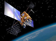
With the advent of geospatial PNT/C2 systems from technology vendors such as GEM elettronica, MicroDAGR, OSI Geospatial, SkyDec, Trimble and others, the modern warfighter enjoys a position of unparalleled informational dominance on land, sea and in the air.
Advanced real-time GIS applications bring navigational accuracy and effective situational awareness to naval vessels while C2 and combat management systems (CMS), ensure that their projection of force role remains uncompromised. In the air, GNSS data guides warplanes to in-flight fuelling rendezvous en route to and from the battle environment. In addition, it enables them to locate and engage their targets, once there, with the sort of accuracy that was once the sole preserve of smart ordnance.
The technology’s value in stand-off conflict is self-evident but as every student of military history knows, ultimately it is only by putting boots on the ground that you win wars. It is hardly surprising, then, that the likes of the US Army Battle Command Systems relies on digital positional reports from all battlefield platform, and the principal source of that vital PNT data is the Navstar global positioning system (GPS). Nor does it come as much of a revelation to find that most US soldiers have bought their own personal GPS receivers – effectively pre-empting Pentagon moves, at least in part, towards their vision of the GIS-integrated land warrior of the future.
Despite their ownership of the constellation of GPS satellites, this is far from a US-only issue. To quote the US Strategic Command, “no other capability permeates the fibre of joint operations like PNT.” It is clear that for the goal of complete command integration to be realised, the components in coalition forces need to be able to draw unified positional data too. Recently awarded contracts from US friends and allies – including the Australian, French and Turkish Navies for geospatial navigation technology and a number of ground forces for various GPS-integrated weapons systems – indicate how seriously they view it themselves.
Navwar
Nevertheless, GPS is now a truly global resource and in a modern battle it will not only be your allies who will be using it. The logical and obvious corollary to placing such dependence on precise PNT in modern military thinking comes in the shape of the enduring necessity to ensure integration of the geospatial informational systems that underpin it.
As a result, the relatively new concept of Navwar has arisen. Here, maintaining geospatial navigational superiority in a dynamic battlefield environment, typically containing intermixed friendly and hostile forces, is crucial. In practical terms, this involves a ‘protect and prevent’ approach, principally falling within the remit of electronic warfare (EW) to employ countermeasures from a variety of platforms to ensure uninterrupted system operation, while denying its use to the enemy.
In some ways, however, perhaps the best measure of just how important the doctrine of geospatial dominance has become can be found in the efforts of potentially hostile powers to disrupt it. According to South Korean sources, for instance, their neighbours to the north have produced a jamming system, apparently based on Russian units similar to those that were used by the Iraqi army at the beginning of the second Gulf War.
Jamming efforts
Although the original units met with little success in that conflict, South Korea understandably fears the potential of such technology on its already tense border. With the North Koreans reputed to be looking for sales in Asia and in the Middle East, other nations are also keeping a careful eye on unfolding events.
The Chinese too are reported to have considerable competence in jamming, having developed effective sophisticated electronics technology that has left the Pentagon watchful of potential exports. Even if the system simply remains at home, the capability to block GPS at will may significantly compromise the operational effectiveness of the US Pacific fleet.
Like all information technologies, PNT capabilities will continue to proliferate, inevitably levelling the playing field between potential combatants. In addition to the established US GPS and Russian GLONASS satellite networks, China has made no secret of its intention to expand its Beidou system to global coverage while the EU’s Galileo system is scheduled to be operational in 2013.
At the other end of the scale, portable localised GPS jammers are already available – despite being widely prohibited – and hacker sites publish detailed DIY instructions for skilled electrical engineers. In the post Cold War era, the notion of asymmetric warfare has irrevocably changed the automatic assumption of technological superiority.
US Directorate of Space Acquisition former principle action officer for PNT policy issues Lt Col Jon M Anderson said, however, that money would play a big part. “Although it is tempting to wait for future technology to fill PNT gaps, there is no assurance that technology can solve these problems affordably.” That being so, facilitating geospatial integration may offer the best way to keep the edge.
