
Red Hen Systems’ commercial-off-the-shelf (COTS) products are used for intelligence, surveillance and reconnaissance (ISR) by the defense industry for ground imagery and corridor patrol operations. Red Hen’s products can be used with any handheld camera or mounted camera to geotag data in photo images or high-definition video from land, sea or air. Once images are geotagged you can import the mission’s data to your desktop and quickly view multimedia maps, including Google Earth, showing the geotagged data.
Red Hen products, which have Bluetooth capabilities, are used real-time in worldwide operations to make decisions requiring precise GPS coordinates, clear images and mapping. They can also be combined with sensors to detect, map and video the location of chemical emissions. Red Hen will help you find the best solutions to fit your needs. Red Hen Systems’ products have been employed by the US Department of Defense since 1998.
Geospatial data logging hardware
The VMS-HDII hardware logs high-definition geospatial data to accompany a mapping interface.
The VMS-HDII’s portable, lightweight design (it weighs less than one pound) is especially suited to collect geotagged ‘path’ HD video from all mobile platforms such as aircraft, ground vehicles and machine vessels. For those familiar with our products, the VMS-HDII is a combination of Red Hen’s VMS-333 with a nanoFlash recorder from Convergent. It includes a feature trigger to mark key points of interest to review after a mission.
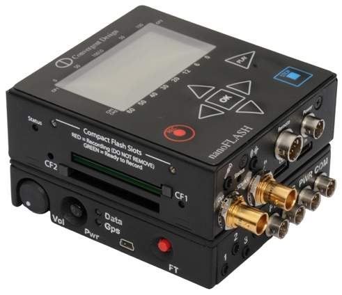
Easily customized to your specifications, this product also includes up to four recording channels for ultraviolet, infrared, standard definition and high definition. When paired with a compatible recording device and Red Hen Systems’ software, videos can be successfully translated to a mapping interface.
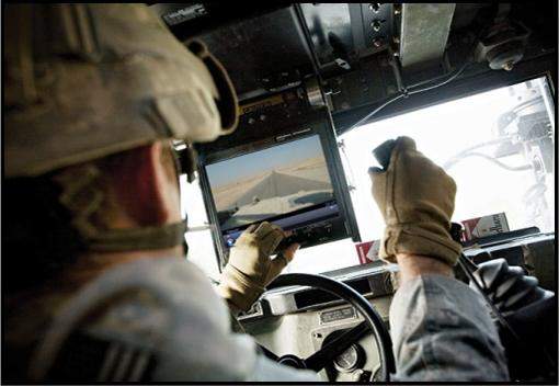
Geospatial media plug-in
RouteScout for FalconView is a plug-in that incorporates geospatial media to improve risk management and analysis.
Route Scout for FalconView extends the mission planning and mapping environment by enabling new methods that exploit geo-spatial ground imagery and other multimedia. It facilitates communication between warfighters and decision makers in the exchange of detailed audiovisual information about a specific route or place.
Red Hen’s MediaGeotagger software delivers geotagged video, photos and audio media typically collected by handheld devices. Data collected by RouteScout is then displayed on a map in order to increase situational awareness.
Android app for robust data collection
MediaMapper Mobile is an Android-based app that complements Red Hen software by providing a COTS field solution for robust data collection.
MediaMapper Mobile creates its own GPX tracking log, allowing you to geotag media collected from a ‘detached’ video or handheld camera in the field using Red Hen’s MediaGeotagger software. Concurrently, the Android’s positional information is associated with photos, points of interest and voice annotations to ensure accurate and detailed data collection from missions.
MediaMapper Mobile completes the workflow cycle by creating Red Hen Project files (.rhproj) that can be imported into Red Hen mapping solutions like the MediaMapper Server and RouteScout for FalconView.
Centralized platform for geotagged photos
Red Hen Systems’ MediaMapper Server includes four client-based tools to upload, organize, view and analyze your important information.
MediaMapper Server helps to improve access to critical decision-making information. It simplifies data recall and analysis, while reducing costs and managing risks. Map Viewer lets users pan and zoom into areas of interest on the map and view any photos and videos at those locations. Users can also search for photos by keywords, location, or date.
The Admin Tool organizes the collected photos and videos into media sets and allows the administrator to set up user accounts and rights. The Image and Video Loader uploads geotagged photos and video to the server, where they’re stored in a ‘media store’. Red Hen’s Server helps do away with per-user licensing costs and eliminates hours of video review and post-processing.